![]()
 A mid-winter announcement in 2016 by the Tarawera overlords indicated a ‘new-look’ Ultra marathon for Feb 2017 with everyone finishing in Kawerau. As is their custom just enough information was given to get the speculation machine turned up to 11 and we have all spend over 5 months wondering exactly what this means for our race.
A heap of forest exploration and careful consideration has resulted in,
- Major changes to the 62km course
- Some changes to the 87km course
- Very minor changes to the 102km course
Wherever possible the course master, Tim Day, has done everything he can to keep courses as close to their traditional 62/87/102km distances however in the interests of delivering the best possible experience you can probably appreciate that some VERY MINOR distance liberties have been taken. It’s looking very much like the actual race-day measurements will come back as 62.9, 87 and 102km respectively. We’ll get into just how that’s happened in the following info/detail.
Have you ever thought “If I could do it all again, I’d do pretty much do it the same but better” ?
One of the best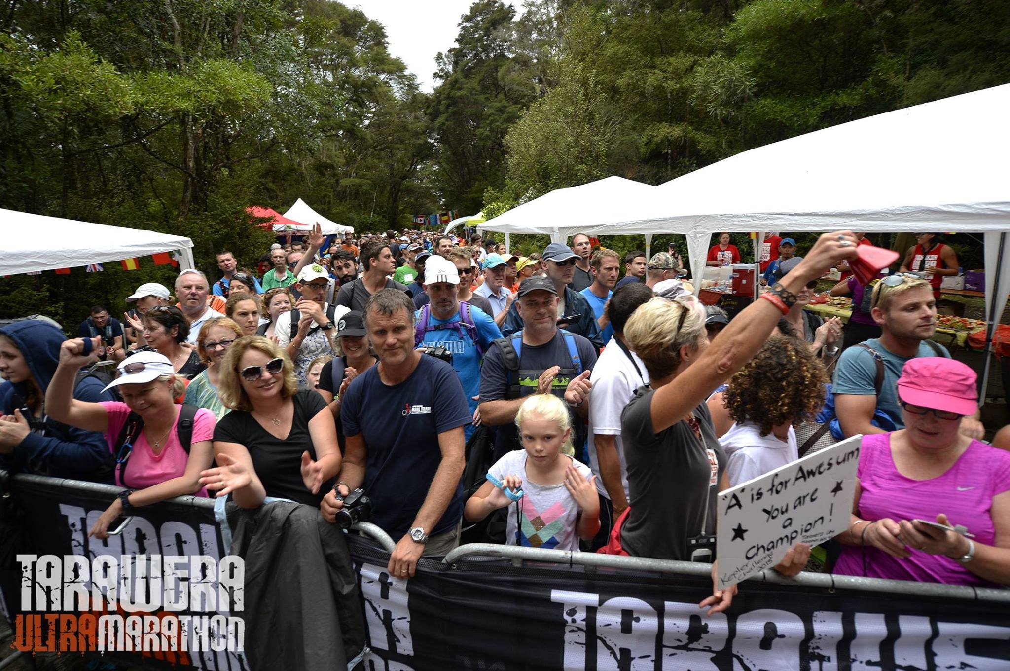 things about a course rework is that you get to seriously look at what is available to you with the intent to deliver a ‘better than ever’ experience. In most cases this is really straight forward but you must remember that the Tarawera Ultra covers a significant amount of WORKING COMMERCIAL forest. It’s a fluid thing that changes annually with some changes being forced and beyond the control of the Race Director and Organiser. It’s a privilege to run these trails in any form and in today’s ‘high-vis vest / traffic-cone’ culture this sort of access is becoming rare and quite special.
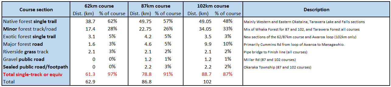
Before we get into the detail I think it useful to understand some differences in running surface and while we often say ‘Forestry Road’ as though it’s one thing, the scope here is quite wide.
Forestry Road – Type 2. Less than 4km of this for ALL courses except the 102km which is relatively unchanged.
Type-1) Forestry Road shared with road traffic (spectator vehicles etc). In year 1 we had something like 20 kilometers of
this and I’m still coughing dust and gravel… In the 2017 edition of Tarawera you’ll share the road with traffic for all of about 20 metres in 1 short road/bridge crossing. LESS THAN EVER BEFORE!
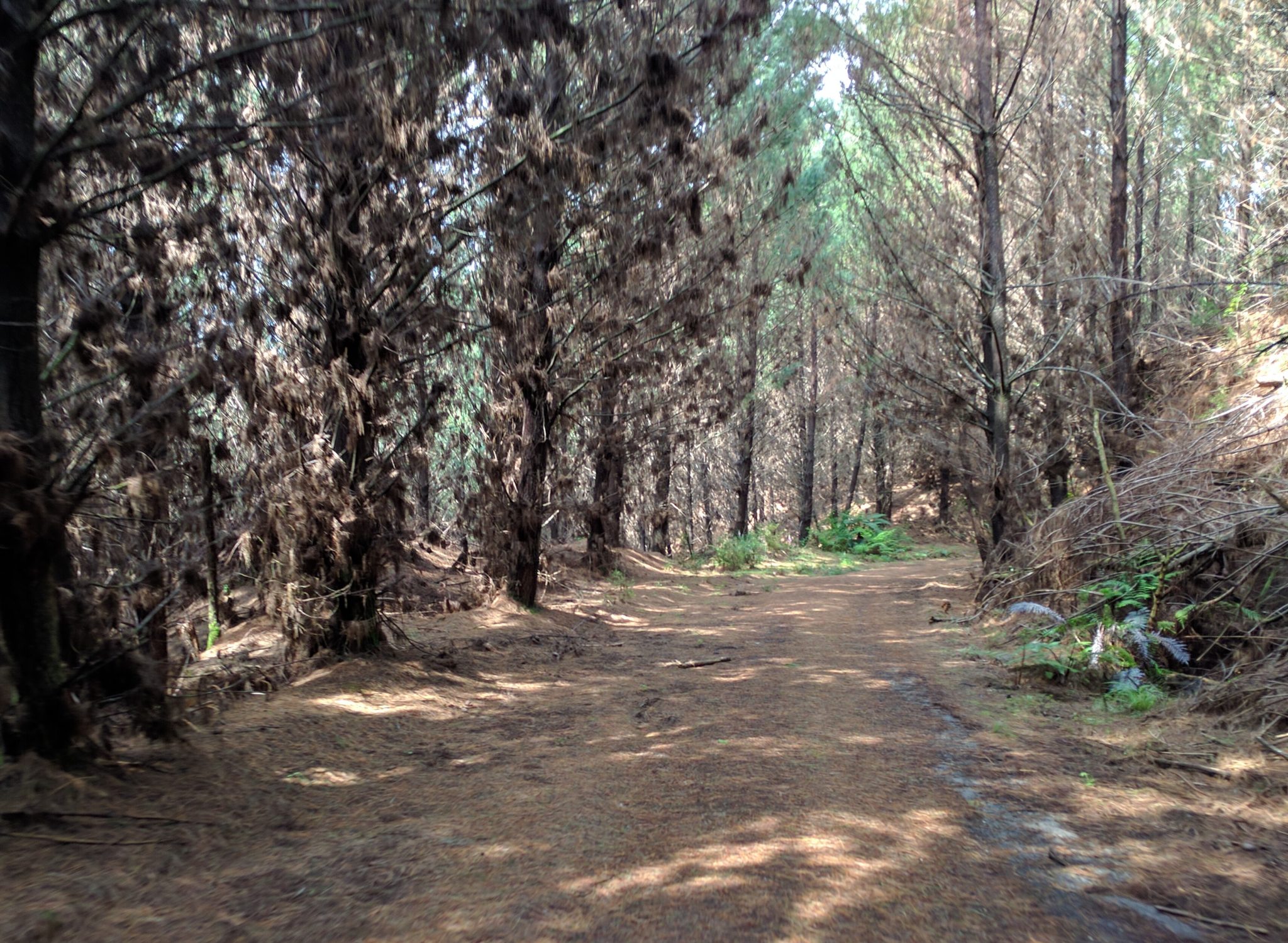
Type-2) Forestry Road that is closed to traffic but you could drive down it and not wreck the paint work on your car. There is and always will be some of this in all 3 distances. It’s a little variable in terms of tree-cover and the ugliest section is really the few kms of Windy road between Lynmore Link and Feeder Track. Elsewhere there is a 300m section following Titoki aid-station and about 1.1km of it soon after Fishermans Bridge aid-station. For all courses except the 102km.
We’re talking less than 4km of this stuff. The long course as always will stick to it’s roots and remain unchanged with that mentally
Forest ROAD? Hardly. Some of the hardships we’ll ALL suffer on the way to Titoki aid-station
challenging sequence of open forestry road (Cummings Rd) from ‘The Loop of Despair’ to the Mangawhio Road shortly before the conflux of all courses by
the Fisherman’s Bridge aid-station. On the plus side, all the trees are 1 year older than this time last year.
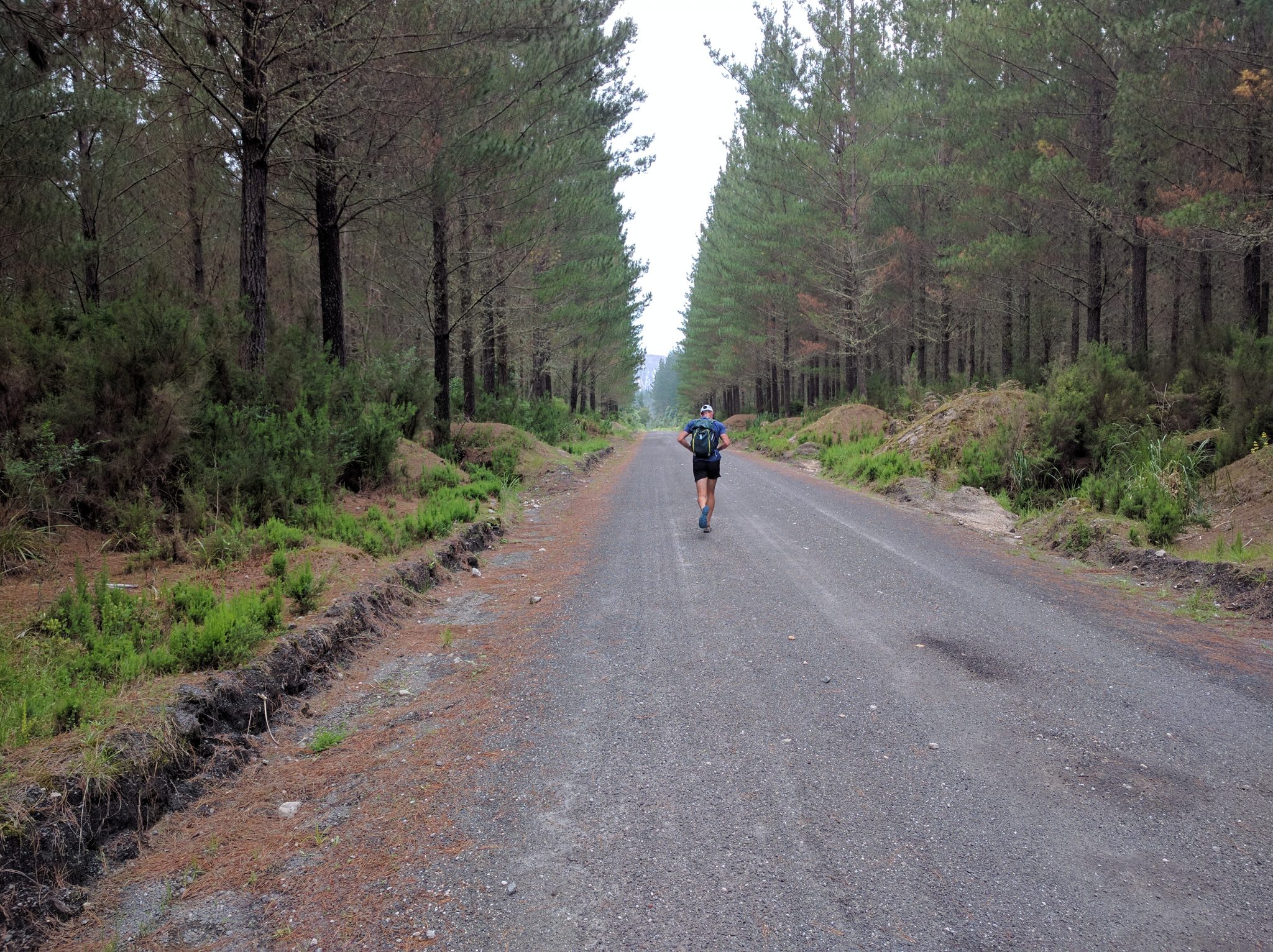
Type-3) Forestry Road that hasn’t seen a vehicle in months, maybe years. If you attempted to drive down this you’d be rewarded with the scrapey sounds of plants-on-paint and the eye-wincing crunch of your exhaust being removed by the terrain. This has to be some of the best running surfaces in New Zealand with Pine needle covered track allowing athletes to run ‘shoulder to shoulder’ with their pacers.
So let’s look at these changes and what they mean for each of the races.
The 62km Ultra
“Everyone finishes in Kawerau” quite simply dictates that unless you’re a really good swimmer, you’re going to have to START somewhere other than the Redwoods Information Centre. 62km from Kawerau backwards puts you somewhere in the middle of the Western Okataina Walkway (WOW). Obviously WOW is an impossible place to get runners to so there are two obvious start locations and the first being to start runners near the Okataina Lake aid-station (boat ramp / car park). A couple of Okataina options here exist in the shape of the Outdoor Education Centre or Boat Ramp carpark itself however logistically this is a very long way to transport A LOT of 62km runners. Buses and buses and buses as well as an early pick-up, make this start location look pretty unattractive. In addition the course would actually end up considerably shorter than 62km unless some extra sequence was added in the Tarawera Forest which would mean a departure from other courses (a third course), more marshalling, marking and complexities worth avoiding. The obvious place to start is the end of Millar Rd at the beginning of the Western Okataina Walkway. Great, so we have a start location for the 62km but what does this mean?
- Busses will transport athletes the 62km distance from Long Mile Rd (Redwoods Info Centre) to the end of Millar Rd.
- Athletes get to see the start of the longer courses and 4-person relay race at Redwoods Info before boarding busses.
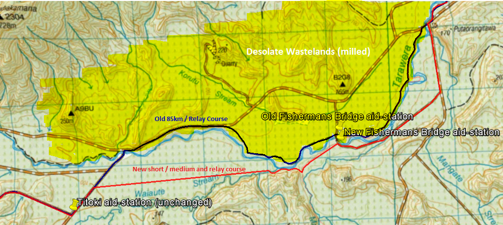
- Athletes skip several kms of Whakarewarewa forestry road (Windy Rd between Lynmore Link and Feeder Track, Milled late 2016).
- Less vert by skipping Tokorangi Pa (previously Tank-to-Town), back of Blue Lake and Millar Road climbs.
Missing out on Feeder track, Blue Lake, Tennents Track, Okareka, Boyes Beach. - Around 4km less public-access Sealed Road and Gravel Road with no Okareka township and Millar Road.
Retention of Western and Eastern Okataina, Tarawera Lake and Tarawera Falls tracks – unchanged (the best bits!). - Everyone get’s to run to Titoki! For those that don’t know it, this bit is LOVELY (see above image). However, there is a bit of a climb in here. Hard up and gentle down so the running is really flowing and surprisingly beautiful under the pines.
- Addition of some of the nicest forestry road (type 3) and arguably the best single-track in the course (sorry 102km runners, you miss this one). What follows is a LOVELY bit of trail we found that the AMAZING Edwina and Sue (Kawerau Gravity Sports) have bashed, trimmed and shaped. This effectively links Titoki to Mangawhio Rd and Fisherman’s Bridge aid-station with almost zero vert, a sweet bridge and true river-side running. Aww yisss!
You will get wet feet. Alongside the Tarawera river. there is a 10m section of knee-deep water to ‘wade’ through along the Puhipuhi stream edge. Charge on through for a nice cooling, or take your shoes off and tiptoe. NB – this also affects the 87km and 4-person relay courses. - From there a slight change for all courses that means no one actually crosses Fisherman’s bridge other than crew and supporters (potential pacer interchange point). Staying on the true right of the river is forced due to the milling operations to the North which was a bit of an additional/unforeseen problem meaning we unavoidably lose a few kms of River Road. But it’s wrecked now, so… boo. The workaround here is to pick up 1.1km of Cummings Rd (Pictured above, Forest Road Type-2, no traffic) before crossing the main road and hooking back into the plush bits of River Road un-mangled by milling operations en route to River Road Aid-station and the Kawerau Finish. NB – this also affects the 87km and 4-person relay courses.
- The Kawerau Finish! Well done 62km runners you made it! For the first time ever you could potentially get a hug from Paul, Tim and yours-truly (cool-kids jet planes shirt required). A bigger-scale finish line than ever before. Beer tent, Medical tent, Beer tent, SQUADRUN hospitality tent, Beer tent, did I mention Beer tent? MASSIVE upgrade in finish line facilities for 62km finishers including hot food (thanks Sequoia Eatery!).
Included in live finishing stream and other finishing media under the gantry and timing clock. Whoop! - Total Distance – this is confirmed as 62.9 however allow up-to 10% either side as your feeble wrist watch is nothing compared to the massive unit (giggle) that Tim carries.
- Reduced sealed road and ‘public access’ gravel road from about 10% in 2016 to effectively 0% in 2017
- You can no longer choose to upgrade your run mid-race (bawww). You will need to decide now-ish if your training is up to one of the longer two options on offer AND COMMIT. There’s still 7 weeks of training, need a hand...?
- 62km athletes will likely have a different coloured bib or race number so they are clearly identifiable. This is to prevent you from turn right at Titoki (accidentally?) and heading towards the loop of despair and attempting to complete what would end-up being a ‘not-medal-worthy’ 77km run. So the Titoki aid-station will be marshalled to ensure this mistake doesn’t happen. Note – TURN LEFT AT TITOKI, the Loop of Despair is a silly place.
- As explained below in the ‘Pacers/Supporters’ section, 62km athletes can see their ‘crew’ at Okataina, Tarawera Falls, Titoki, Fishermans Bridge, and River Rd. A massive increase in accessibility over previous years 62km.
- This also means more aid stations and drop-bag options through the Tarawera Forest. It just keeps getting better!
On balance it’s a pretty clear and apparent upgrade for 62km athletes. You can count the losses as very limited. You’ll miss out on the mass start but the tradeoff is you get to finish with everyone. No Redwoods and Tank-to-town. No Blue Lake and Tennents Track, no Boyes beach, but you avoid sealed road in Okareka township and Millar Rd. While at the same time the additions and upgrades are extensive. The offset to losing Blue Lake (if that was your thing) is you’re going to get some lovely riverside single track we added after Titoki. Along with cool sections you’ve never seen before like Tarawera Falls to Titoki, Mangawhio Rd and River Rd. This edition is more scenic than ever.
The 87km Ultra and 4-Person Relay
Starting in it’s traditional home at Quarry Rd courses will kick-off at the usual time with 62km runners present to cheer you away before they board buses to their remote start location. Expect everything you have already come to love about this start. The adrenaline and atmosphere, the authentic maori ‘haka’ performance. The differences from previous years as follows:
- Turn around! Instead of starting in the Information Center car park and heading UP Quarry Road, we’re spinning 180 degrees and running from Quarry Rd into the car park. WHAT THE DEUCE? WHY?!? Since inception the Tarawera Ultra has struggled in some way with brief bottlenecks on the ‘Black Track’ stairs or in the Redwoods and Tank to Town tracks. The only bottlenecks we’re going to see this time will be in Kawerau after the finish (beers!). In February 2017 we’re going up Nursery Rd! A kilometer or so of closed sealed road but wide enough to get a thousand bobbing headlamps up onto Tokorangi Pa without congestion. And back to our ancestral roots with Tokorangi Pa along the ridgeline with sweet views across town to pre-dawn Lake Rotorua before rejoining ‘Tank To Town’ and ‘Lynmore Link’ as we always have done. NB – this obviously also applies to 102km runners.
- Since the start sequence up Nursery Rd and Tikorangi Pa adds 1.5km (approx), the detour to Direct and Hill Rd is no longer required which means after Lynmore Link we’ll go back to the left-hander to Windy Rd we did every year prior to 2016. The unavoidable impact being the recent milling of Windy rd means it’s a bit of a wasteland for a couple kms prior to Feeder track (formerly the Ponga track).
- The course changes mentioned above in 62km notes #7 and #8 apply to the 87km and 4-person relay courses as well with realignment after Titoki to Fishermans, Mangawhio, Cummings and River rd sections.
- The remainder of the 87km and 4-person relay course will be unchanged. However you will may well get to encounter a few hundred 62km course athletes along your way to Kawerau given they got a head-start on you (cheaters!). Share the trail, meet some friends, spread some rainbows!
- Worth noting is that the single-track addition between Titoki and Mangawhio Rd will be slightly slower and more technical than the previous years running of this race. This will matter most for your leg-4 relay runner who will have less forestry road running. This leg now has a slightly technical component where previously it didn’t. It also got a scenery bump so leg-4 runners are expected to post their on-track selfies with #ThanksTim&Kerry (jokes).
At a glance this is a cool rework for the 87 and 4-person relay course with probably the most notable things being you get to meet a lot of 62km athletes at some stage (the ones you can catch). You no longer have to share the road with ‘Tarawera Falls’ road traffic on River Rd so way less dusty gravelly cough cough. This diversion taking in the awesome riverside section through to Mangawhio Rd before Fishermans bridge aid-station. Net upgrade for the 87km and 4-person relay course. Whoop!
87km and 4-person relay now stays south side instead of crossing the river. Red line follows the NEW section for all except the 102km.
The 102km Ultra
- Refer to the start line change in the 87km ‘Turn around’ note #1 above
- Minor change around Fishermans bridge aid-station with the course now staying on the true right of the Tarawera River instead of crossing the river twice before River Road aid-station (ref image below). If you are picking up pacers here they will need to cross the bridge to meet you on Mangawhio Rd. Super simple stuff.
So nothing major here for the 102km course and pretty much identical apples-for-apples stuff from previous years meaning that tasty 7:45 course record is most certainly up for grabs and expect the women’s record to be well and truly obliterated.
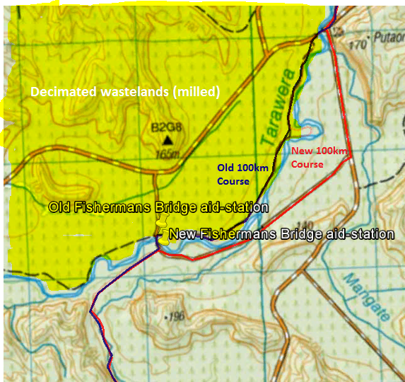
With River Road milled the course now stays true-right
The numbers game
Transfer season!
Obviously the change to the 62km start means you can no longer upgrade to a longer distance if you started the 62km race and your day is going well. You’re just going to have to finish in Kawerau and have a beer with us all. So if you are seriously thinking that the 87km or even 102km distance might be your thing, you’re going to need to transfer your entry prior to race day. Chances are we’re going to have a never-before-seen ‘transfer window’ where you can ask Sarah or the team to bump you up.
If you started the 87 or 102km event and your day went to custard you can no longer downgrade your race and nab a 62km medal. Finishing your day at Tarawera Falls will now result in a DNF and no recorded time for your efforts. There will be a shuttle service and box of tissues at your disposal for the sad ride back to Kawerau where we’ll still share a beer with you and plan for a rematch in 2018.
The likelihood that 62km runners will get printed a race bib that differs significantly from other runners means we really really recommend you make the decision as to which race you want to run THIS YEAR rather than leave it to registration day. If you transfer at registration you risk almost certainly getting a temporary race number without your name and national flag (/symbol) on it.
Refunds? I really doubt it. I’m not across this decision however given all courses are better than ever I don’t believe this option will, or should, exist. Remember Fire and Cyclone course where we all got dealt a rough hand but toughed it out and chose to get through it regardless? Anyone that starts banging on for a refund is, in all probability, looking for a way out because they’ve double-booked themselves, not done the training, gotten injured or various other not-refund-worthy excuses.
ANOTHER EVENT!
Possibly the biggest news is the inclusion of a 2-person relay option with the 62.9km course effectively being split into two equal-ish legs. HOW EXCITING IS THIS?!?!?! Merry Christmas everybody that had decided that perhaps the Ultra Distances were not for them this coming Feb. It’ll look something like this,
- A 33/29 2-person relay race and a chance for a low-cost inclusion in the biggest trail party in NZ
- Leg 1 33km will start at the end of Millar Rd and run through to Tarawera Outlet
- Leg 2 29km will continue from Tarawera Outlet following the 62/87 course through to the Kawerau
At around $140 per-person this is a pretty epic last-minute addition to the portfolio of events and will really suit those Tikitapu runners, the Waitomo masses, those TaraweraMarathon runners not quite ready for the 62 yet, or anyone capable of sticking it out for 30-odd kms of net-downhill jogging between aid-stations. It should prove super easy to find a buddy to take on this awesome new option. The only question-mark being the very real time pinch on designing and delivering a finishers medal (x2). More on this as it comes to hand but assume that you wont get the woodwork to remember you glory.
What all this means for Pacers and Supporters

Pacers are still not an option for the 62km event despite almost half of it taking place in the Tarawera Forest. Pacers are only an option for the 87 and 102km events for cost, various safety and support reasons.
If you’re clever there are some relay->pacer options for both the 4-person and 2-person runners picking up an ultra runner late in day – just remember that you have to collect your pacer bib from Kawerau check-in prior to starting your pacer detail.
Blue lake aid-station wont quite be the mad-house it once was with the 62km runners being down the road a bit. For supporters here this should be a little easier to get to.
For 62km supporters you will be able to see your runner briefly at Okataina provided you use the bus/shuttle option. From there you actually get more opportunity to see and support your 62km runner as they make their way through the Tarawera Forest. Tarawera Falls, Titoki, Fishermans Bridge and River Rd are just some of the places you’ll get to see them in action. Neat!